Aug 30, 2011

Eying TS Katia


Above is TS Katia, the 11th named storm of the 2011 season.  Though it doesn't seem like we've had that many storms we are half way through the 2011 storm names.  Currently Katia is just SW of the Cape Verde islands packing 45mph winds and moving west.  Over the past few days I've been watching Katia develop via satellite images and this is the most organized I've seen the storm yet.

Katia is expected to intensify as she moves west at around 10 knots.   

The map below shows why Katia is becoming better organized and expected to intensify over the next few days.

This is a wind shear map.  It shows areas where wind shear is and whether it is increasing or decreasing.  Wind shear very basically speaking is the result of winds at different altitudes.  For example:  at 50,000ft there is an easterly flow of wind at 50knots and at 30,000ft there is a westerly flow of air blowing at 30knots.  The resulting wind shear would be 20 knots which is a moderate level of shear.  You can see why this would be bad for tropical storm development.  The name says it all, wind shear literally will blow wind the opposite way and shave the top or middle section of a storm apart.

I put an arrow where there is decreasing wind shear next to Katia, which is why Katia has been becoming better organized.  If you look further ahead of Katia there is very little shear or decreasing shear so that is one reason why further intensification is expected.

Whether we get waves or not depends how close she gets to the US coastline and how big she gets.  Computer models are showing Katia take a NW turn way, way, way before she gets close to the US. All which can be said about wave development for our coast depends on how big Katia gets because it looks like she will stay well offshore.  This isn't a bad thing necessarily for wave development.  If Katia gets real big and stays offshore we will most likely get a real long period swell because the waves have time to build and groom themselves.

This is all speculation though.  She's very far away.

MikeC
Aug 27, 2011
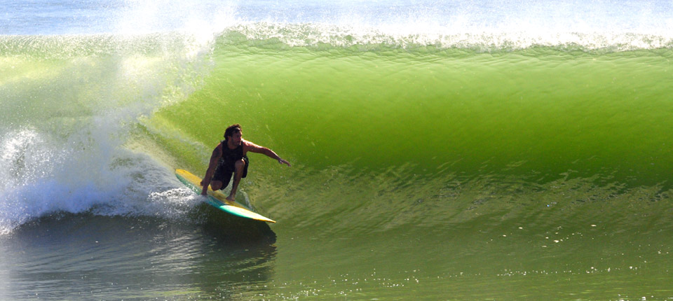
I really shouldn't call it a hit and run 'cause we had good waves the past few days but I was really expecting waves this morning due to the fact it was maxing out at 10+ feet yesterday.  The offshore wind was totally bittersweet.  Yeah, it was clean to an extent yesterday but a 30mph offshore wind sucks.  Too strong.

As I'm going to the beach yesterday I hit a block of traffic with no sign of outgoing traffic.  I thought to myself this is great they closed the beach.  No the beach wasn't closed but a powerline went down right across the first bridge.  Lame.


I still made it though, and saw this....


That's it haters.  I had to go to work.

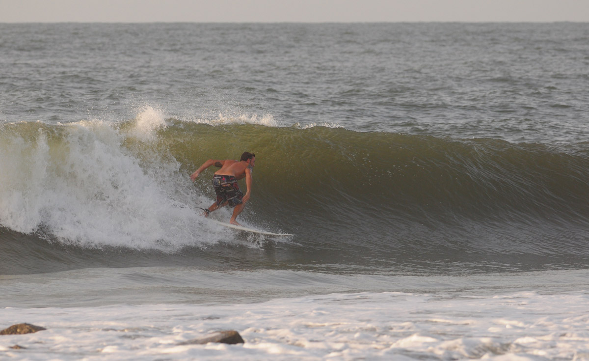
Surfed at the pier? Wanna see if you made the cut?  You're answer lies here: FollyHood.  I wish I surfed the pier judging by Justin's shots.


WARNING: This is a random thought that has nothing to do with surfing:
So North Carolina is currently getting railed by Hurricane Irene and now basically everyone north of NC is bracing for impact.  As you know it is very difficult to predict where hurricanes will travel over the next several days when they first form in the tropical Atlantic.  That way of thinking goes out the window when a hurricane gets closer to the US Coastline.  There are many factors that play into where a hurricane will travel over the next few days when it gets close to the coast that are easily interpreted by computer models and forecasters to determine where a storm will end up.  A good example of what I am trying to say is going on right now.  Have you seen Hurricane Irene's 5 Day Forecast Cone lately?  Well it is pretty narrow.  I mean there is only one way to go which is north.  It's just how it works.

Okay, so what?  

I'm at work last night and it is pretty slow (I valet at a hotel).  Everyone thought the hurricane was going to hit and everyone stayed home.  At times like these when I get bored I go and turn on the radio.  Sometimes its classic rock, sometimes it's rap or today's hits but last night it was talk radio.  Living in the south means you are subjected to listening to Rush, Shnitt, Savage, or some other meatball that fits into the above group.  I listen solely for entertainment.  

Michael Savage is my favorite meatball to listen to.  His abrasive, sarcastic way of explaining things is funny to me.  Best part of his show for sure are his troll listeners that call in and say the stupidest crap ever.  He is so out there with his way of thinking it's hilarious.  

But last night he pissed me off.  Why, is because he kept bashing news stations for covering Hurricane Irene.  It started off funny when he began talking about the reporters that get blasted by wind on the beach.  Then he tried to put on his meteorologist hat and continued to tell his listeners to stop worrying about the storm.  He went on by saying things like, news stations just want ratings, it isn't going to hit any land, "I've been saying this the whole week" (that's his favorite thing to say), it is going out to sea, it won't hit New York, Bloomberg is a leftist freak for shutting down the mass transit.....  

Going out to sea?  Seriously Savage?  Not a good time to act like a meatball this is a seriously dangerous storm.

Complete idiot.
The sad thing is these complete idiots that listen to his show and completely believe anything he says are probably saying to themselves, "Mandatory evacuation!  I'm not letting Obama tell me what to do! I can't wait to call into Savage and tell him they are kicking me out of my house now!!"  Well you won't be calling when the power is out and all your crap floated out to sea because you let a meatball make your decisions for you.  Seriously Savage you are a complete idiot.

Come on Invest 91!

MikeC
Aug 25, 2011
**A TROPICAL STORM WARNING HAS BEEN ISSUED FOR THE CHARLESTON AREA**

Hurricane Irene will be coming very close to us tomorrow.  So close that we are currently under a Tropical Storm Warning.  What that means is that we will experience gusty winds topping out at around 50mph, torrential rain, and of course waves/minor surge.

The image above courtesy of The Weather Channel shows how big an impact Irene's winds will have along the East Coast.  This is why we are under a Tropical Storm Warning.
Shes BIG

I wouldn't venture in to the water.  It is going to be blowing really hard, crossing everything up.  Waves are expected to max out the top spots in the Lowcountry with sets well overhead high.  The Washout even had some trouble today keeping up with the swell and today wasn't even the peak.  

Washout having trouble with some waves.
 As Irene moves up the coast winds are expected to go offshore, hard, Friday night into Saturday morning.  Saturday morning the waves will be dropping quickly so get out early.


The last two days have been really fun!  Unfortunately I couldn't get out Wednesday afternoon due to my job but I was out taking photos early this morning when it was still semi clean.  Here's what I got...


Dece pics. Right?  I'm betting on Saturday morning.

MikeC
Aug 24, 2011
Irene is expected to lash out at the Bahamas today/tonight as a Category 4 Hurricane with sustained winds of 140mph.  The good thing is that Irene's eye wall will track to the east of the Bahamas.  That means the strongest winds will not impact the islands but don't take that statement lightly.  Winds well over hurricane force are still going to hit.

After Irene crushes the Bahamas she is expected to turn more northerly towards the Southeast and Mid-Atlantic states.

***This map updates automatically as new data becomes available***
Right now it looks like South Carolina will dodge a direct hit from Irene.  Friday we could see tropical storm force winds along our coast, flooding, and periodic torrential rain.  Throughout Friday night, Irene will swiftly move northward.  We will feel the back half of Irene Saturday.  This will mostly be a wind event....blowing straight offshore.

Waves

There are waves lapping up on our shore right now from Irene.  Yup they are small but today is the day we begin to see some ground swell fill in.  Remember with a ground swell we need a good incoming tide in order to feel the full effects of the waves.  Shallow water will kill a ground swell so in theory more tide the better.

Today's Waves (Wednesday)

Expect building conditions to about waist high+.

Thursday Waves

Judging how it looks out there right now (Wednesday at 12pm) I think we are going to have some fun waves Thursday.  Consistent waist+ waves building to probably head high+. 

Friday's Waves

Depends how close Irene gets but Friday will most likely be the biggest day because that is when all the swell Irene pushed our way hits us.  I'd say over-my-head plus peaks but wind conditions don't look that good.

Saturday Waves

Get out early for a rapidly cleaning/dropping leftover session.  Judge the size by how big the waves are Friday.

This is depressing but I have work every single day throughout this whole swell event.  I don't have to be at work until 4pmish but still a major hindrance to the blog at me surfing.  I am going to try and work something out.  But guess what?  Justin over at FollyHood has the whole damn thing off so I'm sure he will be posting pictures galore. 

MikeC
Aug 23, 2011
Since yesterday Irene has strengthened to a Category 2 hurricane with sustained winds of 100mph gusting to 120mph.  This storm is very dangerous and the current path has her heading straight for the Carolinas.  


*This map will update as new data becomes available from the NHC.*  It is important to understand with 5 Day Forecasts like this, the average error on day 5 is 250 miles.  On day 4 it is 200 miles.  That means everyone in the above cone needs to watch Irene very carefully.  With that being said tomorrow (Wednesday) we will get a very good idea of where Irene will make landfall.

Two weather systems are impacting both Irene's heading and intensification.  A trough coming off the coast of the eastern seaboard will be forcing Irene on a more NW pattern over the next 2 days.  After that the trough will interact with Irene even more as she gets closer to the United States forcing her due north. 

The second system is affecting Irene's ability to intensify beyond a Cat 3 storm.  Wind shear coming from the SW will be impacting Irene in the short term which will slow any strengthening. 

weather.com
I'm not sure if the Threat Level Map, above, will update automatically.

Tomorrow is the day where we will get a much better idea of where Irene will track.

So any waves?

You know, I really have no clue what the waves are going to look like.  Obviously we are going to get waves but it is highly dependent on where Irene tracks.  If she gets super close to us and makes landfall over Myrtle Beach we will get straight storm surf.  But if she tracks away from the South Carolina we could see another Earl type swell. 

On the other hand we could see waves hitting our coast by Thursday.

Uncertainty, uncertainty, uncertainty.

Now is the time to make a plan BEFORE a storm hits.  Tomorrow will be the day to see if we need to implement our plans.

MikeC
Aug 22, 2011
*****I don't want to scare people right now.  If this was Wednesday I'd say get ready for impact but right now the key word is to MONITOR the forecast.  Don't go running to the stores just yet. Monitor the forecast and review your plan of action.*******


Hurricane Irene is currently a dangerous hurricane lashing out 100mph winds and torrential rain to the island of Puerto Rico.  This is just a preview of what is going to happen to many of the islands of the Caribbean this week and the Georgia/SC coast this weekend.

As I said in my previous post, the computer models are still tightly bound together so forecasters have confidence the above projected path is more accurate than usual. Right now models are suggesting a Major Hurricane/Category 3 storm to directly hit South Carolina.  A category 3 storm is an extremely dangerous storm with sustained winds of 111-130MPH with gusts exceeding 130MPH.  "Devastating damage will occur," says the NHC from the Saffir-Simpson Scale.

This is a little something from The Weather Channel.  It shows the current threat levels or chances of Hurricane Irene hitting certain land masses through Saturday.  Right now we are in the middle of the scale. 
 

Two things can happen to Irene as she moves through the Caribbean.

1. Remember what happened to Emily when she dragged herself over the mountains of Hispaniola?  She got totally crushed and the whole storm dissappered because of the high terrain.  If Irene takes a more SW path over Hispaniola she would most likely downgrade to a lesser storm.

2. But if she continues on the path she is currently on and stays over very, very, very, warm water she could intensify even more.

I don't care if it's only Monday and she isn't expected to come up this way until Friday.  Model guidance for some reason is very uniform and we all must keep a very close eye on this storm this week.

Frequent updates/blog posts will be the name of the game this week.  Keep it tuned here at Folly Surf Photography and also the National Hurricane Center.

MikeC

**GET OFFICIAL HURRICANE UPDATES FROM THE NHC**
Aug 21, 2011
This is the first time I have seen the computer models in such across the board agreement with each other.  With that being said that path of Tropical Storm Irene needs to be closely watched.  Nearly every swell forecast site is predicting victory at sea conditions by this weekend with waves peaking around the 10 foot mark.

Remember though, this is a long term swell forecast so uncertainty is the name of the game.  More details to come.

This map will update as new reports and data become available from Wunderground and the NHC.


MikeC
Aug 18, 2011

Hot 97

Invest 97 is swirling around.  Satellite Imagery is showing it has some nice shape and form.  The storm is super far away still; just off the coast of the Cape Verde Islands.

 
Might get some windswell tomorrow and throughout the weekend.  Probably not worth picture taking.  We will see.  Keep your eye on 97.

MikeC
Aug 14, 2011

Sketch Name for a Storm

Tropical Storm Gert is just south of Bermuda and is not expected to push any sort of swell in our direction.  In fact he is going to get pretty close to Bermuda so be careful if you're planning a trip there.


Invest 92 is also a no go for any swell.  These storms are just too small and a large front is pushing off the coast of the US shepherding all tropical activity northward.  (sad face)


Hopefully this Tropical Season so far has taught you it is extremely difficult to predict what tropical storms are going to do.

MikeC
Aug 12, 2011

Tropics Going Cra Cra!

Tropical Depression 6 doesn't matter.  It's in the 'north Atlantic moving away from the Untied States.

Well I think it's safe to say that we have officially entered the Cape Verde Tropical Season.  This is the time of year we watch huge tropical waves come barreling off the coast of Africa and form into massive hurricanes.  Right now we are watching 4 low pressure systems that have the potential to become tropical cyclones.  Two of those systems have somewhat of a chance of pushing swell in our direction late next week.

Excluding 95L and Tropical Depression 6, 93L right now has the best chance to form into a tropical cyclone.  Although there is some circulation, there is a large mass of dry air to it's north and moderate wind shear not helping things out currently. 93L is also still very far away.

The second storm that could push some swell our way is 92L which is leading 93L.  Less organized than 93L but still showing signs of development 92L is expected to become better organized over the next several days as the wind shear decreases and conditions become more favorable.  Again 92L is leading 93L, but both are really far away.

"Wahhh wahhhh! Mike we know where you get all of your info about storms so stop copying it all!"

No crap I look at Swellinfo but I also like looking at a few maps which most of you haters overlook.

Saharan Air Layer (SAL)

Generally speaking the SAL is the mineral deposits (sand) that get thrown out to sea during large Sahara Desert storms.  It's not hard to put two and two together and figure out dry sandy air isn't good for the formation of tropical storms.

I tried my best to write in the storm number and the direction.  The deeper the red/orange the drier the air.  Notice that the SAL can consume a very large area of ocean. The direction of the storms is approx because it's a little hard to tell when I animate the map.

But you can see how much the SAL influences low pressure systems.  Another thing to remember about the SAL is that winds can be pretty strong.  These strong dry air winds act to shear storms away just like regular wind shear.  So you can see the north side of 93L is interacting with the large region of SAL.  93 is moving due west which will put it in a region of moister air.  92L is suffering not only from wind shear but also a lot of dry air as the map shows. 

This is a good tool to determine short range intensity forecasts of growing storms. 

Over the next week or so I'll post all of the maps I use in conjunction with the literature the NHC puts out.

MikeC
Aug 10, 2011
Unfortunately I have a job that most of the time requires me to work during odd hours.  I was working all day Sunday and didn't get out to the beach until 7pm.  It was heart wrenching to look at the surf cam at 3pm and see everyone having fun on their Sunday off.  All I could do is tell myself there will still be waves when I get off work (an hour before sunset and basically dead low tide).

On the way  I saw cars with boards on their roofs leaving the beach with exhausted occupants inside.  It was a terrible feeling.  When I finally got to the beach it was basically as low as it could get.  Only thing left was a few waist high close out barrels.  But it was still blowing off shore! So I shot a few pictures out of frustration just for you guys, gathered up my board and ran down to the water.  Jumped in and all of a sudden the wind started howling.  Not offshore anymore though.  Straight on.  The stupid jellyfish started stinging me and and by this time everyone was out of the water. I was the only idiot riding, now, waist high mush ball closeouts. 

Don't get me wrong I still had fun so haters don't say, "Kook probably doesn't even surf or go to the beach anymore."  It's easy to tell when everyone is getting frustrated with the surf.  There is a direct correlation to the amount of haters posting on the blog to the amount of days of no surf.  I am glad everyone had fun though.  You needed that.

At least I was making money at work while you people were surfing.

I took 8 pictures at 7pm Sunday.  Three are "worthy" of posting.


Look off the coast of Africa.  Somethings coming...   

MikeC
Aug 7, 2011

T.D. Emily

Signs of Tropical Depression Emily are showing up as I write this.  Only thing is the SW wind is making for some semi choppy conditions.  Let's see what happens as the tide comes up this afternoon.  Yesterday a local storm system rolled through and cleaned things up in a very nice way.  There is a chance for thunderstorms this afternoon so keep an eye out for rapidly cleaning conditions.

MikeC
Aug 5, 2011
Oh yes we can.  The National Hurricane Center (NHC) is giving what remains of Tropical Storm Emily a high chance to form back into a tropical cyclone.  The storm has nearly made it across the high terrain of Hispaniola and now is moving back across warm open waters.  Another good sign is that upper level winds this weekend are looking good to possibly organize Emily once again into a tropical storm.

Here is something else to ponder.  The Cape Verde hurricane season is upon us and the Climate Prediction Center is showing signs of it beginning very soon.  Below you can see a large white and red region just off the coast of the Antilles.  This means that there is a a moderate chance for tropical storm formation; AKA things are looking good for storms to form.  Water is warm, air is moist, and upper level winds are looking decent.


All eyes will be watching if Emily can come back from the dead this weekend.

MikeC
Aug 4, 2011

High Terrain Killed Her

There is no longer a defined center.  No longer any convection.  She is sucking dry Saharan air.  And the high terrain of Hispaniola has killed her.   Emily has officially been downgraded to a low pressure trough.

Only thing we can hope for now is for her to drift northward into open water and maybe strengthen.  That's all.

MikeC
Aug 3, 2011

 Emily is currently located just to the South of Hispaniola.  She is moving West at about 14mph.  Sustained winds are at an average of 50mph.  A few problems have sprung up overnight though....

Satellite imagery is showing an off-centered area of circulation.  This is due to unfavorable upper level winds.  Currently the wind is literally shearing off the top of Emily as she moves forward, which is causing her to become a lopsided storm.  Her winds are stronger on the northern side than her south side.  Not good.  We like to see symmetry.  Another problem ahead of her are the high altitude regions of eastern Cuba and Hispaniola which will act as a speed bump.

There is no chance for intensification today.  We need to wait until she makes it over Hispaniola and Cuba.  Thereafter she will be interacting with a trough which will push her on a northerly path over the Bahamas. Conditions will be conducive in this region for slight strengthening/organization. 

What all this means for Folly

As the days progress we can better forecast where Emily will be located once she reaches our coastline.  Right now though there is still MUCH uncertainty of what type of wave conditions we will see.

SATURDAY

What we do know is that Emily will be just to the south of us Saturday morning.  Wave models are showing a longer period swell filling in throughout Saturday.  How big this swell is depends on the intensity of Emily once she crosses over the Bahamas, which is hard to tell.  All we know is that the swell will most likely be building all Saturday.  Local winds Saturday are expected to be light out of the South.  Slight bump on the water.

SUNDAY

Sunday Emily is expected to be parallel to our coastline.  It is during this time we will be experiencing most of Emily's gift of waves.  Swell charts are low-balling wave heights because there is still an area of uncertainty of her location and intensity as I've said before.  Nonetheless wave heights are expected to be in the 4+ft range.  And since this will be a longer period swell; the waves will have a little punch.  Local winds Sunday are expected to also be light out of the SW.  Again well see a slight bump on the water.

MONDAY

Monday could be our clean up day.  Ha ha for all of you that need to work.  Listen though, Monday is far away but the winds are looking decent at least.  We might see some leftover swell in the 3ft range.  

Lets see what unfolds.

MikeC
Aug 2, 2011

We Need to Watch Emily

Currently, computer models are forecasting Emily to come very close to our coastline towards the end of the weekend.  Some models are predicting she could be come a category 1 storm.  She is still far away but residents from North Carolina to Florida need to keep a close eye on her path.

Nothing much has changed overnight in terms of organization.  If anything she has slowed and began to meander a bit.  Later today she will get back on track moving W NW with little strengthening expected due to some drier weather ahead of her.  Later this week she is expected to be impacted by a trough forcing her on a more northerly path; straight toward us.

If she gets too close to us the surf is going to be stormy and we'll probably experience some heavy rains and coastal flooding.  But if she stays off our coast we could see a quick shot of surf.  Emily will be moving at a quick pace by the time she reaches our coast so unless Emily stalls out the surf won't last long.


Right now it's hard to tell what kind of surf we will get because it is hard to tell how close she will get to the coast.  I'm assuming that is why many of the forecast sites are calling for nothing right now.

Remember though, to keep a close eye on this storm as we get closer to the weekend.

MikeC
Aug 1, 2011
So much for saying Emily will just 'skirt' along the islands of the Caribbean Sea.  Looks like she is going to blast her way across all of them.  Flooding is expected for most of the islands.  Don't go off and buy your tickets to Puerto Rico.  This isn't the storm. 

Maximum sustained winds are currently 40mph gusting to around 50mph.  Emily will be traveling over a mix of land and water over the next week which will stifle any real development.  Nonetheless upper level conditions remain favorable so she is expected to hold her tropical storm title until reaching mostly open waters South of the Bahamas.  When she reaches that point she is expected to form into a hurricane due to the 90 plus degree Caribbean Sea, possibly impacting the Bahamas and southern Florida.

After possibly impacting S. Florida she is expected to turn more northerly, away from the US coastline.  This is all going to happen later this weekend into next week.  Depending how she impacts S. Florida and how close/far she gets from our coast, will depend on what type of waves we get.

Keep an eye on the tropics everyone.

MikeC